Jammu And Kashmir: General Reference Map
The accompanying map provides a general orientation to the geography of the area of the erstwhile princely state of Jammu and Kashmir and will serve as a useful reference for the better comprehension of the series of maps that follow. In the discussion below we consider all areas regarded as parts of the pre-independence state, irrespective of the power (India, Pakistan, or China) that now holds them. In doing this, we take no position either in favor of or against the legality of such possession.
Although the terrain of Jammu and Kashmir is highly diversified, only a small portion of its total area of approximately 85,000 square miles (220,000 square km.) is well suited to human settlement. Of particular note is the fertile Vale of Kashmir, a valley roughly 80 miles long and up to 35 miles wide (130 x 55 km.) astride the upper Jhelum River. This densely settled and surpassingly beautiful area, lies at an average elevation of approximately 5,500 feet (1,675 m.). Held entirely by India, the Vale comprises the core of Kashmir proper. In normal times, it supports an economy based on tourism, handicraft industries and intensive agriculture. Two other favorable areas are of note: the foothills of the Himalayas, together with a narrow strip of the adjoining plain, in Indian-held southern Jammu; and the northwestern extension of that region, comprising the greater part of Pakistani-held Azad Kashmir. These mainly agricultural areas are all relatively well-watered and, where not cleared for cultivation, support rich stands of mainly coniferous forest.
Between southern Jammu and Azad Kashmir on the one hand and the Vale on the other is the Pir Panjal mountain range, which, despite its rugged nature, supports a moderately dense and partially migratory population dependent on largely terraced agriculture, pastoralism, and forestry. Through these mountains must pass the overland traffic connecting the Vale with the plains of India. In the immediate aftermath of the de facto partition of the state in 1947-48, this traffic was funneled through the Banihal Pass, which, at an elevation of 9,290 feet (2,830 meters), was often closed by winter snows. This problem has been mitigated, however, though not entirely eliminated, by the construction of the Jawaharlal Nehru Tunnel at a significantly lower elevation, and by increasing reliance on air transportation. A much easier and formerly much more heavily utilized route to and from the Vale ran through the Baramula Gap by which the Jhelum River flows to what are now Azad Kashmir and Pakistan.
Along the northeastern flank of the Vale runs the main range of the Himalayas. This enormous mountain chain extends from the eastern border region of the North-West Frontier Province of Pakistan southeastward to and well beyond the southern border of Jammu and Kashmir. Forested on their windward southwestern flanks, the Himalayas present a dramatically different, largely barren, aspect to the northeast. There the terrain gives way to the high, arid regions of Pakistani-held Baltistan, administered as a part of the Northern Areas, and Indian-held Ladakh. These two thinly populated regions, comprising well over half the total area of the state, form a western extension of the Plateau of Tibet and are compartmentalized by a series of mountain ranges, generally paralleling the main crest of the Himalayas. They support scattered patches of agriculture, largely dependent on small-scale irrigation works, along with sheep-, goat-, and yak-based pastoralism. An even more barren area, further to the northeast, is known as the Aksai-Chin (White Stone Desert). Held by China since the mid-1950s, it is regarded by India as a part of Ladakh.
The western portion of the Northern Areas, comprising the former Gilgit Agency, is a region of highly variegated, generally mountainous terrain. Through it runs the strategic Karakoram Highway, linking Pakistan with China, and providing access to such fabled, once-isolated locales as Hunza. A thinly populated area, with an economic base similar to that of Ladakh and Baltistan, the region has considerable tourist potential and its Karakoram Mountains, wherein lies K2 (elevation 28,250 ft../ 8,611 m.), the world’s second highest peak, are a mecca for mountaineers.
No discussion of the geography of Jammu and Kashmir would be complete without mention of its great rivers and numerous glaciers. Among the latter are the Baltoro and Siachen Glaciers, the world’s largest outside the polar regions, and the site of continuous military skirmishes between India and Pakistan, the highest battles — and, arguably, the most senseless — fought in all of history. Of the state’s rivers, all but some interior-draining, intermittent streams (mainly in the Aksai Chin) form portions of the Indus drainage basin. The Indus itself originates in Tibet. Along with its major tributaries, the Jhelum and Chenab, it flows out of the state and into Pakistan, which is vitally dependent on their waters for its canal-based irrigation. Another major tributary, the Ravi, flows along the state’s southern border before entering Pakistan. The distribution and use of the waters of the Indus system between India and Pakistan is regulated by the Indus Waters Treaty of 1960.
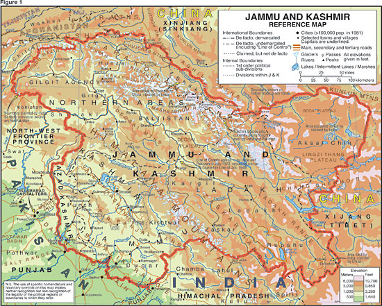
Figure 1: Jammu and Kashmir: General Refernce Map