A HYPOTHETICAL KASHMIRI STATE OR STATES
With Territorial Exchanges between India and Pakistan, Versions D and E
As on figure 6 and figure 7, the following map assumes the concurrence of India and Pakistan in the creation within the area of the erstwhile state of Jammu and Kashmir of either two sovereign, self-governing entities without an international personality, East and West Kashmir, one on each side of the line separating areas controlled by India and Pakistan (Version D), or of a single entity straddling that line (Version E). The suggested nature of such states and the implementation of a process for ascertaining the will of the affected populations would be as previously discussed. But in this presentation it is assumed that the process of creating the two new states or the single state straddling the line will, at some stage, be accompanied by a mutually beneficial exchange of territory between India / East Kashmir and Pakistan / West Kashmir along the general lines indicated on our map entitled "Desirable Territorial Changes Along and Beyond the Line of Control in Jammu and Kashmir" (figure 8). Hence, the areas included within the two new states would reflect those exchanges.
Figure 9 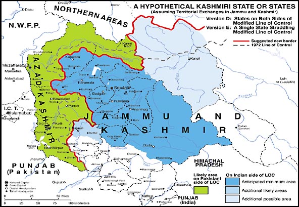
In Version D, on the Indian side of this new boundary, the anticipated minimum area of the new East Kashmiri state would differ from that previously discussed in that the areas to the north and west of the drainage divide between the Neelam / Kishenganga and Jhelum Rivers would be transferred to West Kashmir, while two much smaller areas in the vicinity of Uri would go from West to East Kashmir. Published statistics from the 1981 censuses are not sufficiently detailed to allow us to specify precisely the linguistic make-up of these overwhelmingly Muslim areas; but there can be no doubt that speakers of languages other than Kashmiri (i.e., Pahari, Gojri, and Shina) form a large proportion, if not an outright majority, of the local population. Hence, the transfer of that area to West Kashmiri control would not represent a major loss to ethnic Kashmiris. The population of the areas that East Kashmir would gain close to Uri is also composed mainly of non-Kashmiris (Pahari and Gojri speakers); but it is so small that the territorial transfer would have no significant bearing on the ethnic composition of the state as a whole. Overall, the proposed territorial transfers would probably result in a net loss of population to the East Kashmiri state of less than 100,000.
Because the suggested territorial changes would transfer the whole of Punch district and a small part of Rajauri tahsil (in the district of the same name) to Pakistani / West Kashmiri control, the Indian area to the west of Kashmir proper likely to join the proposed East Kashmiri state would be substantially reduced. Its 1981 population would be approximately 275,000.
To the northeast of Kashmir proper, the proposed territorial transfers would shift to Indian control a relatively large, but thinly populated, Balti-speaking territory that might opt, along with the Baltis of Kargil tahsil, to become a part of the hypothetical East Kashmiri state. The number of persons in the area in question, as of 1981, would likely have been fewer than 50,000.
If the suggested territorial changes were effected, the minimum area of the Kashmiri state on the Indian side of the new border would have had a 1981 population of approximately 3.6 million, while the maximum area would have a population of approximately 3.85 million. Today the maximum area might have a population on the order of 6.15 million.
On the Pakistani / West Kashmiri side of the new border, the proposed transfers of territory would result in a net population gain in the area of what is now Azad Kashmir of more than 350,000, using 1981 data, or approximately 560,000 today. Thus, if all parts of Azad Kashmir choose to be included, the population of the area of the hypothetical, newly constituted sovereign entity of West Kashmir would rise from roughly 3.1 million to nearly 3.7 million. The prospects for the prospective state's viability would be significantly enhanced if the proposed territorial transfers were to be effected.
Under Version E, which envisages a single Kashmiri state straddling the new border, the comments in respect to constitutional arrangements made in reference to Version B would remain applicable. The total population of the hypothetical single Kashmiri state could come to as much as 6.85 million, using 1981 statistics, or roughly 9.2 million today.